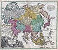
Datei:1730 C. Homann Map of Asia - Geographicus - Asiae-homann-1730.jpg

Originaldatei (4.000 × 3.492 Pixel, Dateigröße: 5,26 MB, MIME-Typ: image/jpeg)

Diese Datei und die Informationen unter dem roten Trennstrich werden aus dem zentralen Medienarchiv Wikimedia Commons eingebunden.

Zur Beschreibungsseite auf Commons


Beschreibung

Johann Christoph Homann: Recentissima Asiae Delineatio : Qua Imperia, eius Regna, et Status, Unacum novissimis Russorum detectionibus circa Mare Caspium et Terram Yedso alias dict. per illor. Expedit. et Excursiones, factis sistuntur.   (Wikidata search (Cirrus search) Wikidata query (SPARQL)  Create new Wikidata item based on this file)
Künstler
Johann Christoph Homann  (1703–1730)  wikidata:Q18508380
 
Beschreibung deutscher Arzt, Verleger und Kartograf
Geburts-/Todesdatum 1703 Auf Wikidata bearbeiten 1730 Auf Wikidata bearbeiten
Geburts-/Todesort Nürnberg Auf Wikidata bearbeiten Nürnberg Auf Wikidata bearbeiten
Wirkungsstätte
Normdatei
artist QS:P170,Q18508380
Titel
Recentissima Asiae Delineatio : Qua Imperia, eius Regna, et Status, Unacum novissimis Russorum detectionibus circa Mare Caspium et Terram Yedso alias dict. per illor. Expedit. et Excursiones, factis sistuntur.
Beschreibung
English: A rare and attractive 18th century map of Asia by German map publisher Johann Christoph Homann. Covers the entire continent of Asia as well as parts of Europe and northeastern Africa. This is essentially a revised and updated version of J. B. Homann’s 1712 map of Asia. Features some interesting and important updates. Most notably, we see the addition of the Kamchatka Peninsula in the upper right hand quadrant. The lower part of the peninsula is labeled “Kurilorum Regio”, no doubt an early reference to the Kuril Islands. While Hokkaido is not present, Japan itself is separated from the mainland by a small archipelago. Just east of these islands we see the Canal de Piecko, and beyond that a large and curious land mass labeled Compagnie Land. Compagnie Land is a mythical landmass that can be traced the work of an unknown Spanish pilot who supposedly traveled from China to New Span and published his finding along with the works of Thevenot. Present in both the 1712 map and this one, Compagnie’s Land could possibly be an early representation of Alaska or a misrepresentation of Hokkaido. Korea or Corea is present if misshapen in roughly the correct location. Further south New Guinea, New Britannia, Australia (New Holland), Hoch Land, and Carpentaria (part of Australia) are personated in tentative form with largely unexplored boundaries. At the center of the map the Caspian Sea is displayed according to the 1722 surveys of Karl van Verden. Bottom left quadrant features a decorative title cartouche displaying an enthroned king in Middle Eastern or Indian garb, exotic animals including a lion and leopard, trade goods, Camels, and bowing supplicants. A spectacular and important 18th century map of Asia.
Datum etwa 1730
date QS:P571,+1730-00-00T00:00:00Z/9,P1480,Q5727902
(undated)
Maße Höhe: 19,5 in (49,5 cm); Breite: 22,5 in (57,1 cm)
dimensions QS:P2048,19.5U218593
dimensions QS:P2049,22.5U218593
Inventarnummer
Geographicus link: Asiae-homann-1730
Herkunft/Fotograf
Genehmigung
(Weiternutzung dieser Datei)
Dies ist eine originalgetreue fotografische Reproduktion eines zweidimensionalen Kunstwerks. Das Kunstwerk an sich ist aus dem folgenden Grund gemeinfrei:
Public domain

Dieses Werk ist gemeinfrei, weil seine urheberrechtliche Schutzfrist abgelaufen ist.
Dies gilt für das Herkunftsland des Werks und alle weiteren Staaten mit einer gesetzlichen Schutzfrist von 100 oder weniger Jahren nach dem Tod des Urhebers.


Parallel zu dieser Lizenz muss auch ein Lizenzbaustein für die United States public domain gesetzt werden, um anzuzeigen, dass dieses Werk auch in den Vereinigten Staaten gemeinfrei ist.
Es wurde festgestellt, dass diese Datei frei von bekannten Beschränkungen durch das Urheberrecht ist, alle verbundenen und verwandten Rechte eingeschlossen.
Nach offizieller Ansicht der Wikimedia Foundation sind originalgetreue Reproduktionen zweidimensionaler gemeinfreier Werke gemeinfrei. Diese fotografische Reproduktion wird daher auch als gemeinfrei in den Vereinigten Staaten angesehen. Die Verwendung dieser Werke kann in anderen Rechtssystemen verboten oder nur eingeschränkt erlaubt sein. Zu Details siehe Reuse of PD-Art photographs.

Kurzbeschreibungen

Ergänze eine einzeilige Erklärung, was diese Datei darstellt.
A rare and attractive 18th century map of Asia by German map publisher Johann Christoph Homann.

In dieser Datei abgebildete Objekte

Motiv

image/jpeg

50d7f41d7c194c9d50a804aaa1b6cba16d8c371b

5.516.217 Byte

3.492 Pixel

4.000 Pixel

Dateiversionen

Klicke auf einen Zeitpunkt, um diese Version zu laden.

Version vomVorschaubildMaßeBenutzerKommentar
aktuell17:35, 16. Mär. 2011Vorschaubild der Version vom 17:35, 16. Mär. 20114.000 × 3.492 (5,26 MB)BotMultichill{{subst:User:Multichill/Geographicus |link=http://www.geographicus.com/P/AntiqueMap/Asiae-homann-1730 |product_name=1730 C. Homann Map of Asia |map_title=Recentissima Asiae Delineatio : Qua Imperia, eius Regna, et Status, Unacum novissimis Russorum detect

Die folgende Seite verwendet diese Datei:

Globale Dateiverwendung

Die nachfolgenden anderen Wikis verwenden diese Datei: