Datei:Bangladesh divisions english.png
Größe dieser Vorschau: 439 × 599 Pixel. Weitere Auflösungen: 176 × 240 Pixel | 500 × 682 Pixel
Originaldatei (500 × 682 Pixel, Dateigröße: 19 KB, MIME-Typ: image/png)
![]()
Diese Datei und die Informationen unter dem roten Trennstrich werden aus dem zentralen Medienarchiv Wikimedia Commons eingebunden.
![]()
Beschreibung
| Beschreibung |
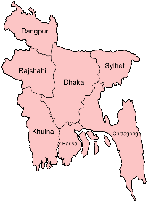
Español: Divisiones de Bangladesh
Map of the divisions of Bangladesh in English. Made by User:Golbez. |
| Datum | 31. Dezember 2005 (Original-Hochladedatum) |
| Quelle | Die Autorenschaft wurde nicht in einer maschinell lesbaren Form angegeben. Es wird angenommen, dass es sich um ein eigenes Werk handelt (basierend auf den Rechteinhaber-Angaben). |
| Urheber | Die Autorenschaft wurde nicht in einer maschinell lesbaren Form angegeben. Es wird Golbez als Autor angenommen (basierend auf den Rechteinhaber-Angaben). |
derivative works
Abgeleitete Werke dieser Datei: Bangladesh location map-Rangpur Division.svg
Lizenz
Ich, der Urheberrechtsinhaber dieses Werkes, veröffentliche es hiermit unter der folgenden Lizenz:

|
Es ist erlaubt, die Datei unter den Bedingungen der GNU-Lizenz für freie Dokumentation, Version 1.2 oder einer späteren Version, veröffentlicht von der Free Software Foundation, zu kopieren, zu verbreiten und/oder zu modifizieren; es gibt keine unveränderlichen Abschnitte, keinen vorderen und keinen hinteren Umschlagtext.
Der vollständige Text der Lizenz ist im Kapitel GNU-Lizenz für freie Dokumentation verfügbar. |
| Diese Datei ist unter der Creative-Commons-Lizenz „Namensnennung – Weitergabe unter gleichen Bedingungen 3.0 nicht portiert“ lizenziert. | ||
| ||
| Diese Lizenzmarkierung wurde auf Grund der GFDL-Lizenzaktualisierung hinzugefügt. |
Diese Datei ist unter der Creative-Commons-Lizenz „Namensnennung 2.5 generisch“ (US-amerikanisch) lizenziert.
- Dieses Werk darf von dir
- verbreitet werden – vervielfältigt, verbreitet und öffentlich zugänglich gemacht werden
- neu zusammengestellt werden – abgewandelt und bearbeitet werden
- Zu den folgenden Bedingungen:
- Namensnennung – Du musst angemessene Urheber- und Rechteangaben machen, einen Link zur Lizenz beifügen und angeben, ob Änderungen vorgenommen wurden. Diese Angaben dürfen in jeder angemessenen Art und Weise gemacht werden, allerdings nicht so, dass der Eindruck entsteht, der Lizenzgeber unterstütze gerade dich oder deine Nutzung besonders.
Du darfst es unter einer der obigen Lizenzen deiner Wahl verwenden.
Dateiversionen
Klicke auf einen Zeitpunkt, um diese Version zu laden.
| Version vom | Vorschaubild | Maße | Benutzer | Kommentar | |
|---|---|---|---|---|---|
| aktuell | 21:40, 27. Jan. 2010 | | 500 × 682 (19 KB) | NordNordWest | update Rangpur |
| 02:28, 1. Mär. 2009 |  | 500 × 682 (19 KB) | Mahahahaneapneap | Compressed | |
| 04:52, 31. Dez. 2005 |  | 500 × 682 (20 KB) | Golbez | Map of the divisions of Bangladesh in English. Made by User:Golbez. Category:Maps of Bangladesh |
Dateiverwendung
Die folgende Seite verwendet diese Datei:
Globale Dateiverwendung
Die nachfolgenden anderen Wikis verwenden diese Datei:
- Verwendung auf ar.wikipedia.org
- Verwendung auf ast.wikipedia.org
- Verwendung auf ca.wikipedia.org
- Verwendung auf en.wikipedia.org
- Wikipedia:WikiProject Bangladesh
- Wikipedia:WikiProject Bangladesh/History Workgroup
- User:Jonny-mt/Gallery of current first-level administrative country subdivisions maps
- Wikipedia:WikiProject Bangladesh/Geography Workgroup
- Talk:Bangladesh/Archive 3
- Wikipedia:WikiProject Bangladesh/ResourcesBangladesh
- Wikipedia:Graphics Lab/Map workshop/Archive/Aug 2010
- Verwendung auf eo.wikipedia.org
- Verwendung auf fi.wikipedia.org
- Verwendung auf fr.wikipedia.org
- Verwendung auf gl.wikipedia.org
- Verwendung auf hi.wikipedia.org
- बांग्लादेश
- सिलहट विभाग
- चट्टग्राम विभाग
- ढाका जिला
- ढाका विभाग
- राजशाही विभाग
- खुलना विभाग
- बरिशाल विभाग
- नरसिंगडी जिला
- मानिकगंज जिला
- मुंशीगंज जिला
- नारायनगंज जिला
- मैमनसिंह जिला
- शेरपुर जिला
- जमालपुर जिला
- नेत्रोकोना जिला
- गाजीपुर जिला (बांग्लादेश)
- किशोरगंज जिला
- टंगाइल जिला
- फरीदपुर जिला
- मदारीपुर जिला
- शरियतपुर जिला
- राजबाड़ी जिला
- बगेरहाट जिला
- चौडांगा जिला
- येशोर जिला
- झेनईदह जिला
- खुलना जिला
- कुश्तिया जिला
- मगुरा जिला
- मेहरपुर जिला
- नराइल जिला
Weitere globale Verwendungen dieser Datei anschauen.