Datei:Carte maine.svg

Größe der PNG-Vorschau dieser SVG-Datei: 800 × 554 Pixel. Weitere aus SVG automatisch erzeugte PNG-Grafiken in verschiedenen Auflösungen: 320 × 222 Pixel | 640 × 443 Pixel | 1.024 × 709 Pixel | 1.280 × 886 Pixel | 2.560 × 1.772 Pixel | 1.813 × 1.255 Pixel
Originaldatei (SVG-Datei, Basisgröße: 1.813 × 1.255 Pixel, Dateigröße: 3,76 MB)
![]()
Diese Datei und die Informationen unter dem roten Trennstrich werden aus dem zentralen Medienarchiv Wikimedia Commons eingebunden.
![]()
Beschreibung
| Beschreibung |
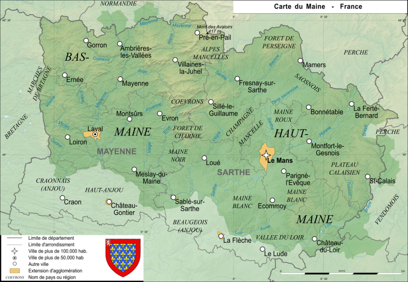
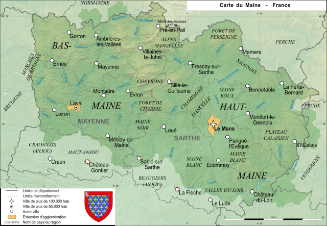
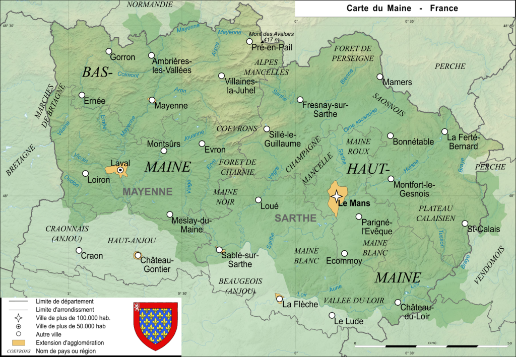
Carte de l'ancienne province française du Maine Map of the ancient french province Maine |
| Datum | |
| Quelle | Eigenes Werk |
| Urheber | User:Esprit04 |
Lizenz
| Ich, der Urheberrechtsinhaber dieses Werkes, veröffentliche es als gemeinfrei. Dies gilt weltweit. In manchen Staaten könnte dies rechtlich nicht möglich sein. Sofern dies der Fall ist: Ich gewähre jedem das bedingungslose Recht, dieses Werk für jedweden Zweck zu nutzen, es sei denn, Bedingungen sind gesetzlich erforderlich. |
Dateiversionen
Klicke auf einen Zeitpunkt, um diese Version zu laden.
| Version vom | Vorschaubild | Maße | Benutzer | Kommentar | |
|---|---|---|---|---|---|
| aktuell | 14:27, 20. Aug. 2021 | | 1.813 × 1.255 (3,76 MB) | Esprit04 | limites |
| 19:23, 5. Feb. 2021 |  | 1.812 × 1.254 (3,41 MB) | Esprit04 | m | |
| 22:32, 4. Feb. 2021 |  | 1.811 × 1.253 (3,38 MB) | Esprit04 | m | |
| 15:21, 1. Feb. 2021 |  | 1.811 × 1.253 (3,38 MB) | Esprit04 | Meilleure version | |
| 23:03, 4. Mai 2011 |  | 2.816 × 2.112 (64 KB) | VIGNERON | ||
| 13:00, 9. Mär. 2008 |  | 2.816 × 2.112 (72 KB) | Esprit04 | {{Information |Description=Carte de l'ancienne province française du Maine Map of the ancient french province Maine |Source=travail personnel |Date=09/03/2008 |Author= Koostia |Permission= |other_versions= }} Category:Sarthe[[Catego | |
| 12:36, 9. Mär. 2008 |  | 2.816 × 2.112 (72 KB) | Esprit04 | {{Information |Description=Carte de l'ancienne province française du Maine Map of the ancient french province Maine |Source=travail personnel |Date=09/03/2008 |Author= Koostia |Permission= |other_versions= }} Category:Sarthe[[Catego | |
| 12:36, 9. Mär. 2008 |  | 2.816 × 2.112 (72 KB) | Esprit04 | {{Information |Description=Carte de l'ancienne province française du Maine Map of the ancient french province Maine |Source=travail personnel |Date=09/03/2008 |Author= Koostia |Permission= |other_versions= }} Category:Sarthe[[Categor | |
| 12:34, 9. Mär. 2008 |  | 2.816 × 2.112 (72 KB) | Esprit04 | {{Information |Description=Carte de l'ancienne province française du Maine Map of the ancient french province Maine |Source=travail personnel |Date=09/03/2008 |Author= Koostia |Permission= |other_versions= }} Category:Sarthe[[Categor | |
| 12:28, 9. Mär. 2008 |  | 2.816 × 2.112 (72 KB) | Esprit04 | {{Information |Description=Carte de l'ancienne province française du Maine Map of the ancient french province Maine |Source=travail personnel |Date=09/03/2008 |Author= Koostia |Permission= |other_versions= }} Category:Sarthe[[Categor |
Dateiverwendung
Die folgende Seite verwendet diese Datei:
Globale Dateiverwendung
Die nachfolgenden anderen Wikis verwenden diese Datei:
- Verwendung auf ca.wikipedia.org
- Verwendung auf en.wikipedia.org
- Verwendung auf es.wikipedia.org
- Verwendung auf fa.wikipedia.org
- Verwendung auf fr.wikipedia.org
- Verwendung auf he.wikipedia.org
- Verwendung auf it.wikipedia.org
- Verwendung auf lfn.wikipedia.org
- Verwendung auf nrm.wikipedia.org
- Verwendung auf pt.wikipedia.org
- Verwendung auf simple.wikipedia.org