Datei:D'Anville Amérique Septentrionale 1746 UTA 2.jpg

Originaldatei (10.547 × 5.851 Pixel, Dateigröße: 7,95 MB, MIME-Typ: image/jpeg)
![]()
Diese Datei und die Informationen unter dem roten Trennstrich werden aus dem zentralen Medienarchiv Wikimedia Commons eingebunden.
![]()
Beschreibung
| Titel |
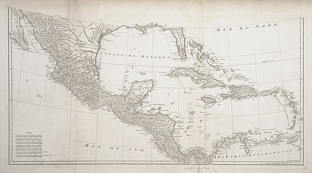
Français : Amérique Septentrionale |
||||||||||||||||||||||||||||||||||||||||||||||
| Beschreibung |
English: The research d'Anville conducted for this map included reading several decades' worth of exploration and travel narratives as well as maps by his predecessors and contemporaries, yet he realized there were still vast areas of the continent where nothing was yet known. D'Anville's map of North America corrected much of the exaggerations and distortions found on Delisle's earlier maps, adding newer, more precise information about the shapes of the Great Lakes and the configuration of the Mississippi basin, including the lower Missouri, Arkansas, and lower Red Rivers. Along the lower Missouri, for example, d'Anville depicted Fort d'Orléans (established in 1723) after carefully studying accounts by its founder, Étienne de Veniard, Sieur de Bourgmont (1679-1734), who had returned to France in 1725 with his Missouria wife and a number of Native American tribal representatives. Important sources for the Gulf coast were the field survey maps of French engineer Valentin Devin (d. 1735), who had first arrived in Louisiana in 1719. |
||||||||||||||||||||||||||||||||||||||||||||||
| Datum | |||||||||||||||||||||||||||||||||||||||||||||||
| Quelle | UTA Libraries Cartographic Connections: Karte / Text | ||||||||||||||||||||||||||||||||||||||||||||||
| Urheber |
|
||||||||||||||||||||||||||||||||||||||||||||||
| Anerkennung |
English: The University of Texas at Arlington Libraries Special Collections |
||||||||||||||||||||||||||||||||||||||||||||||
| Kartografische Angaben | |||||||||||||||||||||||||||||||||||||||||||||||
| Ortsbezug |
Mexiko Zentralamerika Karibik |
||||||||||||||||||||||||||||||||||||||||||||||
| Georeferenzierung | If inappropriate please set warp_status = skip to hide. | ||||||||||||||||||||||||||||||||||||||||||||||
| Bibliographische Angaben | |||||||||||||||||||||||||||||||||||||||||||||||
| Urheber |
|
||||||||||||||||||||||||||||||||||||||||||||||
| Erscheinungsort | Paris | ||||||||||||||||||||||||||||||||||||||||||||||
| Drucker |
|
||||||||||||||||||||||||||||||||||||||||||||||
| Archivalische Angaben | |||||||||||||||||||||||||||||||||||||||||||||||
| Sammlung |
|
||||||||||||||||||||||||||||||||||||||||||||||
| Maße | Höhe: 46 cm; Breite: 87 cm | ||||||||||||||||||||||||||||||||||||||||||||||
| Technik | handkolorierter Stich auf Papier | ||||||||||||||||||||||||||||||||||||||||||||||
| Inschriften |
Français : Publiée sous les auspices de Monseigneur le duc d'Orleans, prémier prince du sang / par le Sr. D'Anville, MDCCXLVI. |
||||||||||||||||||||||||||||||||||||||||||||||
| artwork-references |
L'Italien, Raymonde; Jean-François Palomino, Denis Vaugeois; Kathe Roth, transl. (1995) Mapping a Continent: Historical Atlas of North America, 1492-1814, Sillery, Quebec: Les editions du Septentrion, S. 58−96 Jackson, Jack (2007) Flags Along the Coast: Charting the Gulf of Mexico, 1519-1759: A Reappraisal, Austin: The Book Club of Texas, S. 193 Huseman, Ben W. (2016) Enlightenment Mapmakers and the Southwest Borderlands: Treasures from the Virginia Garrett Cartographic History Library, Arlington: UTA Libraries Special Collections, Nr. 13 , S. 16−17 |
||||||||||||||||||||||||||||||||||||||||||||||
| Andere Versionen |
|
||||||||||||||||||||||||||||||||||||||||||||||


Lizenz

|
This file was provided to Wikimedia Commons by the University of Texas at Arlington Libraries as part of a cooperation project. The University of Texas at Arlington Libraries is part of the University of Texas at Arlington, a public research university located in Arlington, Texas.
|
|
Der Urheber dieses Werks ist 1782 gestorben; es ist daher gemeinfrei, weil seine urheberrechtliche Schutzfrist abgelaufen ist. Dieses Werk ist gemeinfrei in den Vereinigten Staaten, weil es vor dem 1. Januar 1929 veröffentlicht (oder beim U.S. Copyright Office registriert) wurde. | |
| Es wurde festgestellt, dass diese Datei frei von bekannten Beschränkungen durch das Urheberrecht ist, alle verbundenen und verwandten Rechte eingeschlossen. | |
Dateiversionen
Klicke auf einen Zeitpunkt, um diese Version zu laden.
| Version vom | Vorschaubild | Maße | Benutzer | Kommentar | |
|---|---|---|---|---|---|
| aktuell | 22:18, 29. Mai 2019 | | 10.547 × 5.851 (7,95 MB) | Michael Barera | == {{int:filedesc}} == {{Map |title = ''Amérique Septentrionale'' |description = {{en|The research d'Anville conducted for this map included reading several decades' worth of exploration and travel narratives as well as maps by his predecessors and contemporaries, yet he realized there were still vast areas of the continent where nothing was yet known. D'Anville's map of North America corrected much of the exaggerations and distortions found on Delisle's earlier maps, addi... |
Dateiverwendung
Die folgende Seite verwendet diese Datei:
Globale Dateiverwendung
Die nachfolgenden anderen Wikis verwenden diese Datei:
- Verwendung auf en.wikipedia.org
- Verwendung auf fr.wikipedia.org
- Verwendung auf it.wikipedia.org
- Verwendung auf pt.wikipedia.org