Datei:Death and Panamint valleys from space.jpg

Death_and_Panamint_valleys_from_space.jpg (486 × 412 Pixel, Dateigröße: 40 KB, MIME-Typ: image/jpeg)

Diese Datei und die Informationen unter dem roten Trennstrich werden aus dem zentralen Medienarchiv Wikimedia Commons eingebunden.

Zur Beschreibungsseite auf Commons


Beschreibung

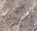
English: Satellite picture of Death Valley, the Panamint Range, Panamint Valley, and Mojave Desert from space.
  • The elliptical depression to the left is the Searles Lake basin, the smaller linear valley is Panamint Valley and the larger one is Death Valley.
  • The mountain range between Death and Panamint Valleys is the Panamint Range, and the Black Mountains bound the other side of Death Valley.


(NASA image Archivkopie in der Wayback Machine)"

moved here from the English Wikipedia: http://en.wikipedia.org/wiki/Image:Death_and_Panamint_valleys_from_space.JPG

Lizenz

Public domain Diese Datei ist gemeinfrei (public domain), da sie von der NASA erstellt worden ist. Die NASA-Urheberrechtsrichtlinie besagt, dass „NASA-Material nicht durch Urheberrecht geschützt ist, wenn es nicht anders angegeben ist“. (NASA-Urheberrechtsrichtlinie-Seite oder JPL Image Use Policy).
Warnung:

Kurzbeschreibungen

Ergänze eine einzeilige Erklärung, was diese Datei darstellt.

In dieser Datei abgebildete Objekte

Motiv

Dateiversionen

Klicke auf einen Zeitpunkt, um diese Version zu laden.

Version vomVorschaubildMaßeBenutzerKommentar
aktuell17:25, 31. Mär. 2006Vorschaubild der Version vom 17:25, 31. Mär. 2006486 × 412 (40 KB)MSchnitzler2000"The Death and Panamint valleys area from space. The elliptical depression to the left is the Searles Lake basin, the smaller linear valley is Panamint Valley and the larger one is Death Valley. The mountain range between Death and Panamint valleys is the

Die folgende Seite verwendet diese Datei:

Metadaten