Datei:Deutschland-Karte.jpg

Originaldatei (1.500 × 2.083 Pixel, Dateigröße: 3,67 MB, MIME-Typ: image/jpeg)
![]()
Diese Datei und die Informationen unter dem roten Trennstrich werden aus dem zentralen Medienarchiv Wikimedia Commons eingebunden.
![]()
Beschreibung
| Beschreibung |
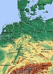
Deutsch: Liste der Berge auf der Karte : Alpen, Bayerische Alpen, Bayerischer Wald, Böhmerwald, Eifel, Erzgebirge, Fichtelgebirge, Frankenwald, Harz, Hunsrück, Jura, Oberpfälzer Wald, Rhön, Rothaargebirge, Schwäbische Alb, Schwarzwald, Taunus, Thüringer Wald, Vogelsberg, Vogesen, Westerwald.
|
| Datum | |
| Quelle | physicalmap.org |
| Urheber | physicalmap.org |
Lizenz
- Dieses Werk darf von dir
- verbreitet werden – vervielfältigt, verbreitet und öffentlich zugänglich gemacht werden
- neu zusammengestellt werden – abgewandelt und bearbeitet werden
- Zu den folgenden Bedingungen:
- Namensnennung – Du musst angemessene Urheber- und Rechteangaben machen, einen Link zur Lizenz beifügen und angeben, ob Änderungen vorgenommen wurden. Diese Angaben dürfen in jeder angemessenen Art und Weise gemacht werden, allerdings nicht so, dass der Eindruck entsteht, der Lizenzgeber unterstütze gerade dich oder deine Nutzung besonders.
- Weitergabe unter gleichen Bedingungen – Wenn du das Material wiedermischst, transformierst oder darauf aufbaust, musst du deine Beiträge unter der gleichen oder einer kompatiblen Lizenz wie das Original verbreiten.
Dateiversionen
Klicke auf einen Zeitpunkt, um diese Version zu laden.
| Version vom | Vorschaubild | Maße | Benutzer | Kommentar | |
|---|---|---|---|---|---|
| aktuell | 22:46, 16. Jun. 2022 | | 1.500 × 2.083 (3,67 MB) | Maps world | modify image |
| 18:06, 3. Jun. 2022 |  | 1.500 × 2.083 (3,84 MB) | Maps world | modify image | |
| 16:06, 14. Mai 2022 |  | 1.500 × 2.083 (3,79 MB) | Maps world | modify image | |
| 23:52, 29. Jan. 2022 |  | 1.500 × 2.083 (3,75 MB) | Maps world | modify image | |
| 21:37, 29. Dez. 2020 |  | 1.500 × 2.083 (3,75 MB) | Maps world | modify information | |
| 21:19, 29. Dez. 2020 |  | 1.500 × 2.083 (3,75 MB) | Maps world | modify information | |
| 18:40, 12. Dez. 2020 |  | 1.500 × 2.083 (3,75 MB) | Maps world | modify information | |
| 16:45, 1. Dez. 2020 |  | 1.500 × 2.083 (3,81 MB) | Maps world | modify information | |
| 13:40, 11. Aug. 2020 |  | 1.500 × 2.083 (4,02 MB) | Maps world | Neue Informationen hinzufügen. | |
| 12:47, 2. Jul. 2020 |  | 1.500 × 2.083 (3,86 MB) | Maps world | Verbesserung der Kartenzusammensetzung |
Dateiverwendung
Die folgende Seite verwendet diese Datei: