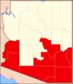
Datei:Diocese of Tuscon Map.png
Diocese_of_Tuscon_Map.png (351 × 407 Pixel, Dateigröße: 7 KB, MIME-Typ: image/png)
Dateiversionen
Klicke auf einen Zeitpunkt, um diese Version zu laden.
| Version vom | Vorschaubild | Maße | Benutzer | Kommentar | |
|---|---|---|---|---|---|
| aktuell | 14:19, 30. Mai 2018 |  | 351 × 407 (7 KB) | Farragutful | adjusted color |
| 11:10, 17. Feb. 2015 |  | 351 × 407 (7 KB) | Sumiaz | Added Navajo/Hopi Nations and county borders for Phoenix Diocese map | |
| 10:34, 17. Feb. 2015 |  | 351 × 407 (6 KB) | Sumiaz | Error in previous upload | |
| 10:29, 17. Feb. 2015 |  | 351 × 407 (6 KB) | Sumiaz | Fixed border | |
| 10:27, 17. Feb. 2015 |  | 432 × 407 (6 KB) | Sumiaz | Removed Gila River Indian Community portion from Pinal County | |
| 20:06, 26. Sep. 2012 |  | 351 × 407 (10 KB) | Farragutful | User created page with UploadWizard |
Dateiverwendung
Die folgende Seite verwendet diese Datei:
Globale Dateiverwendung
Die nachfolgenden anderen Wikis verwenden diese Datei:
- Verwendung auf en.wikipedia.org
- Verwendung auf es.wikipedia.org
- Verwendung auf fr.wikipedia.org
- Verwendung auf id.wikipedia.org
- Verwendung auf it.wikipedia.org
- Verwendung auf jv.wikipedia.org
- Verwendung auf no.wikipedia.org
- Verwendung auf ru.wikipedia.org
- Verwendung auf www.wikidata.org
