Datei:East of England Counties.png

Größe dieser Vorschau: 663 × 599 Pixel. Weitere Auflösungen: 266 × 240 Pixel | 531 × 480 Pixel | 850 × 768 Pixel | 1.133 × 1.024 Pixel | 1.593 × 1.440 Pixel
Originaldatei (1.593 × 1.440 Pixel, Dateigröße: 1,06 MB, MIME-Typ: image/png)
Dateiversionen
Klicke auf einen Zeitpunkt, um diese Version zu laden.
| Version vom | Vorschaubild | Maße | Benutzer | Kommentar | |
|---|---|---|---|---|---|
| aktuell | 16:33, 31. Mär. 2022 |  | 1.593 × 1.440 (1,06 MB) | Ulamm | neighbouring regions with pale labels |
| 12:37, 31. Mär. 2022 |  | 1.593 × 1.440 (1,07 MB) | Ulamm | improvements of colour code | |
| 11:34, 24. Mär. 2022 |  | 1.593 × 1.440 (1,07 MB) | Ulamm | Labelling of surroundings | |
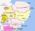
| 10:58, 24. Mär. 2022 |  | 1.593 × 1.440 (1,1 MB) | Ulamm | {{Information |Description={{en|Map of the East of England region, showing its counties and administrative districts. The county colours are the same as those in File:English metropolitan and non-metropolitan counties 2009.svg. Equirectangular map projection on WGS 84 datum, with N/S stretched 160% Geographic limits: *West: 0.8W *East: E *North: N *South: 51.4N }} |Source=File:East of England counties 2019 map.jpg, {{Derived from|East_of_England_districts_2... |
Dateiverwendung
Die folgenden 2 Seiten verwenden diese Datei:


