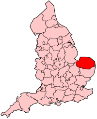
Datei:EnglandNorfolk.png
EnglandNorfolk.png (200 × 247 Pixel, Dateigröße: 26 KB, MIME-Typ: image/png)
Dateiversionen
Klicke auf einen Zeitpunkt, um diese Version zu laden.
| Version vom | Vorschaubild | Maße | Benutzer | Kommentar | |
|---|---|---|---|---|---|
| aktuell | 15:00, 19. Jun. 2005 |  | 200 × 247 (26 KB) | Airunp | From en:Image:EnglandNorfolk.png map of admin county {{GFDL}} en:Norfolk es:Norfolk Category:Maps of Great Britain |
Dateiverwendung
Die folgende Seite verwendet diese Datei:
Globale Dateiverwendung
Die nachfolgenden anderen Wikis verwenden diese Datei:
- Verwendung auf af.wikipedia.org
- Verwendung auf be.wikipedia.org
- Verwendung auf cs.wikipedia.org
- Verwendung auf cv.wikipedia.org
- Verwendung auf cy.wikipedia.org
- Verwendung auf da.wikipedia.org
- Verwendung auf en.wikipedia.org
- User:Morwen/Allcounties
- Cromer Tunnel
- Aylsham Bypass Tunnel
- Category:Schools in Norfolk
- Bloodgate Hill Iron Age Fort
- Bedingham
- Bromholm Priory
- Category:Wikipedia requested photographs in Norfolk
- Shelton Hall (Norfolk)
- Church of St Margaret, Breckles
- Mutton's Mill
- Lambridge Mill
- Moulton St Mary
- Pulls Ferry, Norwich
- Manor Farm, Pulham Market
- Template:Norfolk-struct-stub
- County Ground, Lakenham
- Norwich Bus Station
- Category:Private schools in Norfolk
- Letton Hall
- Clayrack Drainage Mill
- Palmer's Drainage Windmill
- North Norfolk District Council Headquarters
- Blakeney Windmill
- Starston Windpump
- Stubb Drainage Windmill
- List of schools in Norfolk
- Bewilderwood
- Somerleyton Swing Bridge
- Norfolk Nelson Museum
- Gissing Hall
- Windham Manor
- Shropham Hall
- Blackborough Priory
- Coxford Priory
- Crabhouse Priory
- Docking Priory
- Flitcham Priory
- Hickling Priory
- Horsham St. Faith Priory
- Horstead Priory
- Ingham Priory
- Benedictine Priory, King's Lynn
Weitere globale Verwendungen dieser Datei anschauen.

