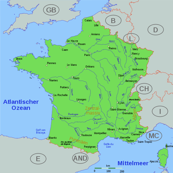
Datei:France cities.svg

Größe der PNG-Vorschau dieser SVG-Datei: 600 × 600 Pixel. Weitere aus SVG automatisch erzeugte PNG-Grafiken in verschiedenen Auflösungen: 240 × 240 Pixel | 480 × 480 Pixel | 768 × 768 Pixel | 1.025 × 1.024 Pixel | 2.049 × 2.048 Pixel | 1.797 × 1.796 Pixel
Originaldatei (SVG-Datei, Basisgröße: 1.797 × 1.796 Pixel, Dateigröße: 383 KB)
Dateiversionen
Klicke auf einen Zeitpunkt, um diese Version zu laden.
| Version vom | Vorschaubild | Maße | Benutzer | Kommentar | |
|---|---|---|---|---|---|
| aktuell | 09:43, 23. Sep. 2006 |  | 1.797 × 1.796 (383 KB) | Thire | no far away countries, bigger cities, tried css, minor things, cher, ... |
| 08:14, 20. Sep. 2006 |  | 1.797 × 1.796 (366 KB) | Thire | now plain svg, not inkscape (thanks fZap at www.inkscape-forum.de) | |
| 17:41, 19. Sep. 2006 |  | 1.797 × 1.796 (384 KB) | Thire | countrynames, NL rivers | |
| 08:01, 19. Sep. 2006 |  | 1.797 × 1.796 (385 KB) | Thire | typo: Pyrenäen | |
| 07:58, 19. Sep. 2006 |  | 1.797 × 1.796 (385 KB) | Thire | grey other countries, rivers just in france, mountains, details, ... | |
| 17:55, 17. Sep. 2006 |  | 1.797 × 1.796 (349 KB) | Thire | {{Information| |Description = map of France with cities and rivers |Source = inkscape and the files below helped me. if you edit it: be aware of the fact that I added some CSS by hand (cities, ...) |Date = 17 sep. 2006 |Author = [[:de:Benutzer:Thire|Thoma |
Dateiverwendung
Die folgenden 3 Seiten verwenden diese Datei:
Globale Dateiverwendung
Die nachfolgenden anderen Wikis verwenden diese Datei:
- Verwendung auf bg.wikipedia.org
- Verwendung auf da.wikipedia.org
- Verwendung auf hu.wikipedia.org
- Verwendung auf incubator.wikimedia.org
- Verwendung auf qu.wikipedia.org
- Verwendung auf uk.wikipedia.org