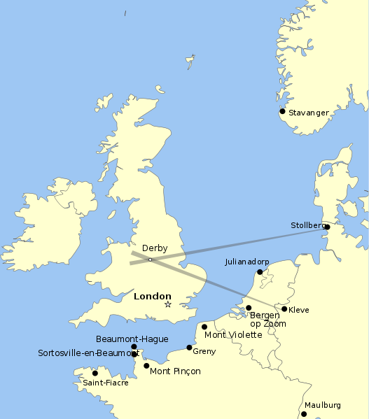
Datei:Map of Knickebein transmitters.svg

Größe der PNG-Vorschau dieser SVG-Datei: 527 × 599 Pixel. Weitere aus SVG automatisch erzeugte PNG-Grafiken in verschiedenen Auflösungen: 211 × 240 Pixel | 422 × 480 Pixel | 676 × 768 Pixel | 901 × 1.024 Pixel | 1.802 × 2.048 Pixel | 658 × 748 Pixel
Originaldatei (SVG-Datei, Basisgröße: 658 × 748 Pixel, Dateigröße: 112 KB)
Dateiversionen
Klicke auf einen Zeitpunkt, um diese Version zu laden.
| Version vom | Vorschaubild | Maße | Benutzer | Kommentar | |
|---|---|---|---|---|---|
| aktuell | 07:47, 26. Aug. 2011 |  | 658 × 748 (112 KB) | Chriusha | Position of K 11 corrected, see Disk |
| 16:38, 13. Mai 2011 |  | 658 × 748 (112 KB) | Hohum | More readable text. | |
| 23:18, 21. Apr. 2010 |  | 658 × 748 (113 KB) | Dahnielson | Made the beams nicer, changed the Stollberg label and hopefully fixed the font rendering. Category:Radio navigation Category:Battle of Britain | |
| 23:14, 20. Apr. 2010 |  | 658 × 748 (114 KB) | Dahnielson | Added Julianadorp and Bergen op Zoom to map | |
| 22:50, 20. Apr. 2010 |  | 658 × 748 (111 KB) | Dahnielson | Added transmitter locations and the Kleve/Stollberg beams targeting Derby as an example. | |
| 20:19, 20. Apr. 2010 |  | 658 × 748 (103 KB) | Dahnielson | Reverted to version as of 18:47, 20 April 2010 | |
| 20:18, 20. Apr. 2010 |  | 658 × 748 (103 KB) | Dahnielson | Try to fix the font issue. | |
| 19:47, 20. Apr. 2010 |  | 658 × 748 (103 KB) | Dahnielson | {{Information |Description={{en|1=Map showing the positions of Knickebein transmitters during the battle of Britain.}} |Source={{own}} |Author=Dahnielson |Date=2010-04-20 |Permission= |other_versions= }} |
Dateiverwendung
Die folgende Seite verwendet diese Datei:
Globale Dateiverwendung
Die nachfolgenden anderen Wikis verwenden diese Datei:
- Verwendung auf ar.wikipedia.org
- Verwendung auf en.wikipedia.org
- Verwendung auf es.wikipedia.org
- Verwendung auf fr.wikipedia.org
- Verwendung auf he.wikipedia.org
- Verwendung auf sk.wikipedia.org
