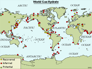
Datei:Methane Clathrate Location Map USGS.gif
Methane_Clathrate_Location_Map_USGS.gif (363 × 274 Pixel, Dateigröße: 19 KB, MIME-Typ: image/gif)
Dateiversionen
Klicke auf einen Zeitpunkt, um diese Version zu laden.
| Version vom | Vorschaubild | Maße | Benutzer | Kommentar | |
|---|---|---|---|---|---|
| aktuell | 20:50, 12. Apr. 2007 |  | 363 × 274 (19 KB) | Eintragung ins Nichts | {{Information |Description=Locations of known and inferred gas hydrate (methane clathrate) occurrences in oceanic sediments of outer continental margins and permafrost regions. |Source=[http://energy.usgs.gov/other/gashydrates/] |Date= |Author=U.S. Geolo |
Dateiverwendung
Die folgende Seite verwendet diese Datei:
Globale Dateiverwendung
Die nachfolgenden anderen Wikis verwenden diese Datei:
- Verwendung auf be.wikipedia.org
- Verwendung auf cs.wikipedia.org
- Verwendung auf en.wikipedia.org
- Verwendung auf pl.wikipedia.org
- Verwendung auf pt.wikipedia.org
- Verwendung auf ru.wikipedia.org
- Verwendung auf uk.wikipedia.org


