Datei:NPS kenai-fjords-map.jpg

Größe dieser Vorschau: 589 × 599 Pixel. Weitere Auflösungen: 236 × 240 Pixel | 472 × 480 Pixel | 755 × 768 Pixel | 1.007 × 1.024 Pixel | 2.014 × 2.048 Pixel | 3.050 × 3.102 Pixel
Originaldatei (3.050 × 3.102 Pixel, Dateigröße: 2,1 MB, MIME-Typ: image/jpeg)
![]()
Diese Datei und die Informationen unter dem roten Trennstrich werden aus dem zentralen Medienarchiv Wikimedia Commons eingebunden.
![]()
Beschreibung
| Beschreibung |
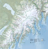
English: Full Kenai Fjords map, showing the Exit Glacier area as well as the fjords and islands southwest of Seward. |
| Datum | |
| Quelle | U.S. National Park Service (http://npmaps.com/wp-content/uploads/kenai-fjords-map.jpg) |
| Urheber | U.S. National Park Service, restoration/cleanup by Matt Holly |
| Andere Versionen |
 |
Lizenz
| Diese Datei ist ein Werk eines Mitarbeiters des National Park Service (NPS) der Vereinigten Staaten, aufgenommen oder hergestellt während seiner offiziellen Anstellung. Als ein amtliches Werk der Bundesregierung der Vereinigten Staaten ist dieses Bild gemeinfrei. (Nähere Informationen dazu sind auf der offiziellen Website des NPS verfügbar.) |
Dateiversionen
Klicke auf einen Zeitpunkt, um diese Version zu laden.
| Version vom | Vorschaubild | Maße | Benutzer | Kommentar | |
|---|---|---|---|---|---|
| aktuell | 01:30, 17. Mai 2017 | | 3.050 × 3.102 (2,1 MB) | RKBot | =={{int:filedesc}}== {{Information |description= {{en|1=Full Kenai Fjords map, showing the Exit Glacier area as well as the fjords and islands southwest of Seward.}} |date= 2015-08-15 |source= U.S. National Park Service (http://npmaps.com/wp-content/up... |
Dateiverwendung
Die folgende Seite verwendet diese Datei:
Globale Dateiverwendung
Die nachfolgenden anderen Wikis verwenden diese Datei:
- Verwendung auf en.wikipedia.org
- Verwendung auf fr.wikipedia.org
- Verwendung auf it.wikipedia.org
- Verwendung auf www.wikidata.org