Datei:North-west-Coast of North America and adjacent Territories Compiled from the best authorities under the direction of Robert (MAPS 42).jpg
.jpg)
.jpg&action=edit&redlink=1)

Originaldatei (6.572 × 4.925 Pixel, Dateigröße: 7,07 MB, MIME-Typ: image/jpeg)
![]()
Diese Datei und die Informationen unter dem roten Trennstrich werden aus dem zentralen Medienarchiv Wikimedia Commons eingebunden.
![]()
.jpg?uselang=de)
|
|
|
This image was automatically transferred from the collections of the University of Washington. While certainly the majority of metadata in their database is correct, it is not necessarily written by individuals who are expert on the material they are describing. Such images often have incorrect dates, locations, or other information. If you can verify that this information is correct, or correct it if it isn't, please do so and remove this template. Also, if you are correcting information, please also let the library know so that they can update the metadata on their site. You can contact UW LIBRARIES MSCUA at photos |
Beschreibung
| Titel |
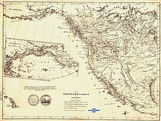
English: North-west-Coast of North America and adjacent Territories Compiled from the best authorities under the direction of Robert Greenhow to accompany his Memoir on the North-west Coast Published by order of the Senate of the United States drawn by David H. Burr |
|||||||||||||||||||||||
| Beschreibung |
English: Copper engraving. Mounted on cloth. Relief shown by hachures. Printed in center above bottom border: "The North-west-Coast of North America and adjacent Territories compiled from the best authorities under the direction of Robert Greenhow to accompany his Memoir on the Northwest Coast Published by order of the Senate of the United States drawn by David H. Burr. Note. The names of places on the border of the map show their respective Latitudes." Printed in north Pacific Ocean is an inset map of North Pacific Ocean showing islands, eastern coast of Asia and western coast of North America. Printed next to title is an imprint of a medal from 1787 given to two ships bound to explore the northwest coast of North America, the "Columbia" and "Washington," commanded by J. Kendrick with the legend: "Fac-Simile of a Medal struck at Boston in 1787 on occasion of the departure of the vessels Columbia and Washington for the North West Coast of America, taken from one of the original Medals, deposited by the Hon. C. Cushing, in the Library of the Department of State of the United States." Printed at top of map along longitude 140 degrees west: "Boundary between Gt. Britain 7 Russia by Convention of 1825." Printed at approximately latitude 41 degrees north in northwest United States: "boundary between united States & Spain by treaty of 1818." Printed at approximately latitude 47 degrees north: "Between the United States and Great Britain by treaty of 1818." Shows California peninsula as "Old California" and northern California as "New California." Labels modern-day British Columbia as "New Caledonia." Shows Alaska as "Russian Possession." Depicts a range of mountains near California as the "Snow Mountains." Prime Meridian: Greenwich and Washington, D.C. Scale c.a. 1:12,250,000. [W 175 degrees-W 80 degrees/N 65 degrees-N 15 degrees].David H. Burr (1803-1875) was Topographer to the Post Office and Geographer to the House of Representatives of the United States Congress. His works include “Universal Atlas” (1835), “Atlas New York” (1829), “American Atlas” (1839), “United States” (1842), “Ohio” published by Colton (1845) and “World” (1850). Robert Greenhow (1800-1854) was a physician, scientist, linguist and historian. He worked as translator and librarian to the State Department. His works include “Memoir, Historical and Political, on the Northwest Coast…” (1840) and “West Coast of North America” manuscript (1844) (Tooley 262; “The north-west-coast of North America…”). This particular map signifies the efforts the United States made towards claiming territory in the northwest against the British in the 1840s. Robert Greenhow created a book, “Memoir…” describing the history, politics and geographical nature of the northwest to assist the Senate in determining its case against Great Britain. This map was created for Greenhow’s “Memoir…” published in 1840. The map shows a range of mountains near California labeled as “Snowy Mountains.” According to Wheat, the map looks like Laurie’s 1838 map except for the Lost, Adams, Ashley and Inconstant Rivers. Apparently, both Laurie and Burr borrowed much from the work of another cartographer, John Arrowsmith. Greenhow later took his initial book and expanded it into a larger worker, “History of California and Oregon” (Wheat, 254, entry 447; “The north-west-coast of North America…). Source(s): ”The north-west-coast of North America and adjacent Territories Compiled from the best authorities under the direction of Robert Greenhow to accompany his Memoir on the Northwest Coast (1840).” Early Washington Maps: A Digital Collection at Washington State University Libraries Digital Collection. 2008. Tooley, Ronald Vere. “Tooley’s Dictionary of Mapmakers.” Hertfordshire: Map Collector Publications Limited, 1979. Wheat, Carl I. “Mapping the Transmississippi West.” Volume 2. San Francisco: Institute of Historical Cartography, 1957.
|
|||||||||||||||||||||||
| Publisher | United States Senate | |||||||||||||||||||||||
| Printer | Blair and Rives | |||||||||||||||||||||||
| Digital ID Number | MAP167 | |||||||||||||||||||||||
| Condition | Wrinkles throughout leaf. Original call number written in ink in lower left margin. Blue stamp in middle of bottom edge: "Library University of Washington Seattle." Call number written in pencil on verso in lower left corner. | |||||||||||||||||||||||
| Datum | ||||||||||||||||||||||||
| Quelle |
English: World and Regional Maps Collection |
|||||||||||||||||||||||
| Urheber |
English: Burr, David H. English: Robert Greenhow English: United States Senate |
|||||||||||||||||||||||
| Genehmigung (Weiternutzung dieser Datei) |
|
|||||||||||||||||||||||
| Kartografische Angaben | ||||||||||||||||||||||||
| Ortsbezug | North America | |||||||||||||||||||||||
| Georeferenzierung | If inappropriate please set warp_status = skip to hide. | |||||||||||||||||||||||
| Bibliographische Angaben | ||||||||||||||||||||||||
| Publikation |
"Memoir, Historical and Political, on the Northwest Coast of North America, and the Adjacent Territories Illustrated by a Map and a Geographical View of Those Countries." Greenhow, Robert. Washington, D.C.: Blair and Rives, Printers, 1840. Senate executive document (United States. Congress. Senate); 26th Congress, 1st Session, no. 174. |
|||||||||||||||||||||||
| Erscheinungsort | Washington, D.C. | |||||||||||||||||||||||
| Archivalische Angaben | ||||||||||||||||||||||||
| Sammlung |
|
|||||||||||||||||||||||
| Inventarnummer | ||||||||||||||||||||||||
| Maße | Höhe: 39 cm; Breite: 54 cm | |||||||||||||||||||||||
Dateiversionen
Klicke auf einen Zeitpunkt, um diese Version zu laden.
| Version vom | Vorschaubild | Maße | Benutzer | Kommentar | |
|---|---|---|---|---|---|
| aktuell | 07:35, 8. Jul. 2022 | | 6.572 × 4.925 (7,07 MB) | BMacZeroBot | Batch upload (Commons:Batch uploading/University of Washington Digital Collections) |
Dateiverwendung
Die folgende Seite verwendet diese Datei:
Globale Dateiverwendung
Die nachfolgenden anderen Wikis verwenden diese Datei:
- Verwendung auf en.wikipedia.org
.jpg)