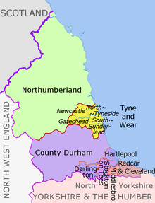
Datei:North East England counties 2009 map.svg

Größe der PNG-Vorschau dieser SVG-Datei: 482 × 599 Pixel. Weitere aus SVG automatisch erzeugte PNG-Grafiken in verschiedenen Auflösungen: 193 × 240 Pixel | 386 × 480 Pixel | 618 × 768 Pixel | 824 × 1.024 Pixel | 1.647 × 2.048 Pixel | 1.082 × 1.345 Pixel
Originaldatei (SVG-Datei, Basisgröße: 1.082 × 1.345 Pixel, Dateigröße: 723 KB)
Dateiversionen
Klicke auf einen Zeitpunkt, um diese Version zu laden.
| Version vom | Vorschaubild | Maße | Benutzer | Kommentar | |
|---|---|---|---|---|---|
| aktuell | 21:16, 14. Aug. 2018 |  | 1.082 × 1.345 (723 KB) | Inops | change letters labelling the boroughs of Tyne and Wearfrom white to black. Hardly intelligible when thumbnailed otherwise |
| 21:11, 5. Mai 2012 |  | 1.082 × 1.345 (723 KB) | Dr Greg | lighten black boundary line | |
| 23:21, 1. Mai 2012 |  | 1.082 × 1.345 (723 KB) | Dr Greg | == {{int:filedesc}} == {{Information |Description={{en|Map of the North East England region of England, showing its counties and administrative districts. The county colours are the same as those in [[:File:English metropolitan... |
Dateiverwendung
Die folgende Seite verwendet diese Datei:
Globale Dateiverwendung
Die nachfolgenden anderen Wikis verwenden diese Datei:
- Verwendung auf ar.wikipedia.org
- Verwendung auf ca.wikipedia.org
- Verwendung auf en.wikipedia.org
- Verwendung auf es.wikipedia.org
- Verwendung auf fa.wikipedia.org
- Verwendung auf fr.wikipedia.org
- Verwendung auf hu.wikipedia.org
- Verwendung auf ja.wikipedia.org
- Verwendung auf lv.wikipedia.org
- Verwendung auf mr.wikipedia.org
- Verwendung auf pl.wikipedia.org
- Verwendung auf pnb.wikipedia.org
- Verwendung auf th.wikipedia.org
- Verwendung auf ur.wikipedia.org
- Verwendung auf vi.wikipedia.org
- Verwendung auf vls.wikipedia.org
- Verwendung auf zh-yue.wikipedia.org


