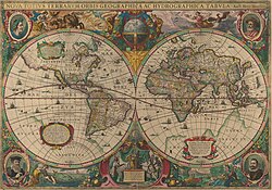
Datei:Nova totius Terrarum Orbis geographica ac hydrographica tabula (Hendrik Hondius) balanced.jpg

Größe dieser Vorschau: 800 × 562 Pixel. Weitere Auflösungen: 320 × 225 Pixel | 640 × 450 Pixel | 1.024 × 720 Pixel | 1.280 × 900 Pixel | 2.560 × 1.799 Pixel | 5.248 × 3.688 Pixel
Originaldatei (5.248 × 3.688 Pixel, Dateigröße: 5,3 MB, MIME-Typ: image/jpeg)
Dateiversionen
Klicke auf einen Zeitpunkt, um diese Version zu laden.
| Version vom | Vorschaubild | Maße | Benutzer | Kommentar | |
|---|---|---|---|---|---|
| aktuell | 00:09, 7. Feb. 2008 |  | 5.248 × 3.688 (5,3 MB) | Hesperian | {{Information |Description=This is an image of ''Nova totius Terrarum Orbis geographica ac hydrographica tabula'', a map of the world created by Hendrik Hondius in 1630, and published the following year in the atlas ''Atlantis Maioris Appendix |
Dateiverwendung
Die folgenden 2 Seiten verwenden diese Datei:
Globale Dateiverwendung
Die nachfolgenden anderen Wikis verwenden diese Datei:
- Verwendung auf en.wikipedia.org
- Verwendung auf fa.wikipedia.org
- Verwendung auf fy.wikipedia.org
- Verwendung auf it.wikipedia.org
- Verwendung auf ja.wikipedia.org
- Verwendung auf ru.wikipedia.org
- Verwendung auf sl.wikipedia.org
- Verwendung auf uk.wikipedia.org
- Картографія
- Козьма Індикоплевст
- Проєкція Меркатора
- Leo Belgicus
- Глобус
- Гекатей Мілетський
- Педру Рейнел
- Мадабська карта
- Карта Пірі-реїса
- Портолан
- Користувач:Orestsero
- Земне яблуко
- Шаблон:Карти і глобуси
- Глобус Блау
- Готторпський глобус
- Mappa mundi
- Ягеллонський глобус
- Туринська папірусна карта
- Вавилонська карта світу
- Йоганн Шонер
- Orbis terrae
- Theatrum Orbis Terrarum
- Maris Pacifici
- Велике креслення
- Космографія Блау
- Carta marina
- Планісфера Кантіно
- Пейтингерова таблиця
- Куньюй Ваньго Цюаньту
- Карта Мао Куня
- Книга Рожера
- Християнська топографія
- Карта Вінланду
- Нільська мозаїка
- Герефордська карта
- Карта де Вірга
- Ебсторфська карта
- Каталанський атлас
- Каннідо
- Карта Вальдземюллера
Weitere globale Verwendungen dieser Datei anschauen.


