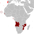
Datei:Portuguese colonial war map1.PNG
Portuguese_colonial_war_map1.PNG (360 × 392 Pixel, Dateigröße: 12 KB, MIME-Typ: image/png)
Dateiversionen
Klicke auf einen Zeitpunkt, um diese Version zu laden.
| Version vom | Vorschaubild | Maße | Benutzer | Kommentar | |
|---|---|---|---|---|---|
| aktuell | 11:17, 5. Mär. 2008 |  | 360 × 392 (12 KB) | The Ogre | Enhanced visualization |
| 20:51, 26. Nov. 2007 |  | 360 × 392 (12 KB) | Hoshie | added Cabinda, updated base map | |
| 15:46, 12. Aug. 2006 |  | 360 × 392 (12 KB) | Nuno Tavares | == Summary == Map of the Portuguese colonies in Africa by the time of the Portuguese Colonial War (1961-1974). ==Source== <pre> 12:19, 8 April 2006 . . Mário (Talk | contribs) . . 360×392 (12,409 bytes) (Map of the Portuguese colonies i |
Dateiverwendung
Die folgende Seite verwendet diese Datei:
Globale Dateiverwendung
Die nachfolgenden anderen Wikis verwenden diese Datei:
- Verwendung auf en.wikipedia.org
- Verwendung auf fr.wikipedia.org
- Verwendung auf ja.wikipedia.org
- Verwendung auf pt.wikipedia.org

