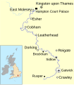
Datei:River Mole Map.svg

Größe der PNG-Vorschau dieser SVG-Datei: 450 × 515 Pixel. Weitere aus SVG automatisch erzeugte PNG-Grafiken in verschiedenen Auflösungen: 210 × 240 Pixel | 419 × 480 Pixel | 671 × 768 Pixel | 895 × 1.024 Pixel | 1.789 × 2.048 Pixel
Originaldatei (SVG-Datei, Basisgröße: 450 × 515 Pixel, Dateigröße: 269 KB)
Dateiversionen
Klicke auf einen Zeitpunkt, um diese Version zu laden.
| Version vom | Vorschaubild | Maße | Benutzer | Kommentar | |
|---|---|---|---|---|---|
| aktuell | 16:42, 14. Feb. 2010 |  | 450 × 515 (269 KB) | Mertbiol | Still trying to get text to display correctly |
| 16:31, 14. Feb. 2010 |  | 450 × 515 (273 KB) | Mertbiol | Attempt to sort out crop issues | |
| 16:27, 14. Feb. 2010 |  | 674 × 772 (165 KB) | Mertbiol | Size page and attempt to sort out problem displaying text. | |
| 15:53, 14. Feb. 2010 |  | 744 × 1.052 (168 KB) | Mertbiol | {{Information |Description={{en|1=Map of the River Mole in south east England}} |Source={{own}} |Author=Mertbiol |Date=2010-02-14 |Permission= |other_versions= }} Map created using data from the Open Source Maps. Category:Surrey |
Dateiverwendung
Die folgende Seite verwendet diese Datei:
Globale Dateiverwendung
Die nachfolgenden anderen Wikis verwenden diese Datei:
- Verwendung auf cy.wikipedia.org
- Verwendung auf it.wikipedia.org
- Verwendung auf pl.wikipedia.org
- Verwendung auf sh.wikipedia.org
- Verwendung auf www.wikidata.org
