Datei:ShizuokaMapCurrent.png

Größe dieser Vorschau: 800 × 500 Pixel. Weitere Auflösungen: 320 × 200 Pixel | 640 × 400 Pixel | 1.024 × 640 Pixel | 1.281 × 801 Pixel
Originaldatei (1.281 × 801 Pixel, Dateigröße: 30 KB, MIME-Typ: image/png)
![]()
Diese Datei und die Informationen unter dem roten Trennstrich werden aus dem zentralen Medienarchiv Wikimedia Commons eingebunden.
![]()
Beschreibung
| Beschreibung |
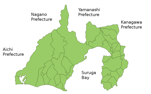
Map of Shizuoka Prefecture, Japan. Thanks to Aoki Shigenobu and [1]. Colors from Image:TokyoMapCurrent.png by User:Fg2. |
| Datum | 19. Juli 2006 (Original-Hochladedatum) |
| Quelle | Die Autorenschaft wurde nicht in einer maschinell lesbaren Form angegeben. Es wird angenommen, dass es sich um ein eigenes Werk handelt (basierend auf den Rechteinhaber-Angaben). |
| Urheber | Die Autorenschaft wurde nicht in einer maschinell lesbaren Form angegeben. Es wird Akanemoto~commonswiki als Autor angenommen (basierend auf den Rechteinhaber-Angaben). |
Lizenz
| Ich, der Urheberrechtsinhaber dieses Werkes, veröffentliche es als gemeinfrei. Dies gilt weltweit. In manchen Staaten könnte dies rechtlich nicht möglich sein. Sofern dies der Fall ist: Ich gewähre jedem das bedingungslose Recht, dieses Werk für jedweden Zweck zu nutzen, es sei denn, Bedingungen sind gesetzlich erforderlich. |
Dateiversionen
Klicke auf einen Zeitpunkt, um diese Version zu laden.
| Version vom | Vorschaubild | Maße | Benutzer | Kommentar | |
|---|---|---|---|---|---|
| aktuell | 06:34, 30. Mär. 2021 | | 1.281 × 801 (30 KB) | AichiWikiFixer | update |
| 00:12, 29. Sep. 2011 |  | 1.281 × 801 (42 KB) | Haaninjo | Mergers into Fujieda, Fujinomiya and Kosai | |
| 06:02, 1. Nov. 2008 |  | 1.281 × 801 (43 KB) | Alberth2 | ||
| 19:38, 19. Jul. 2006 |  | 1.281 × 801 (42 KB) | Akanemoto~commonswiki | Map of Shizuoka Prefecture, Japan. Thanks to Aoki Shigenobu and [http://aoki2.si.gunma-u.ac.jp/map/map.html]. Colors from Image:TokyoMapCurrent.png by User:Fg2. Category:Maps of Shizuoka prefecture Category:Maps in English |
Dateiverwendung
Keine Seiten verwenden diese Datei.
Globale Dateiverwendung
Die nachfolgenden anderen Wikis verwenden diese Datei:
- Verwendung auf az.wikipedia.org
- Verwendung auf ckb.wikipedia.org
- Verwendung auf cs.wikipedia.org
- Verwendung auf eu.wikipedia.org
- Verwendung auf fi.wikipedia.org
- Verwendung auf hu.wikipedia.org
- Verwendung auf jv.wikipedia.org
- Verwendung auf lt.wikipedia.org
- Verwendung auf ms.wikipedia.org
- Verwendung auf no.wikipedia.org
- Verwendung auf pl.wikipedia.org
- Verwendung auf ru.wikipedia.org