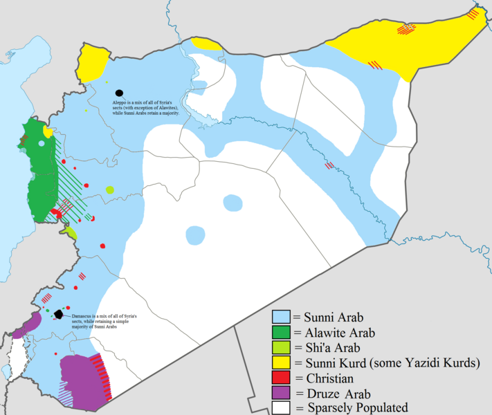
Datei:Syria Ethnoreligious Map.png

Größe dieser Vorschau: 711 × 600 Pixel. Weitere Auflösungen: 285 × 240 Pixel | 569 × 480 Pixel | 910 × 768 Pixel | 1.214 × 1.024 Pixel | 1.778 × 1.500 Pixel
Originaldatei (1.778 × 1.500 Pixel, Dateigröße: 373 KB, MIME-Typ: image/png)
Dateiversionen
Klicke auf einen Zeitpunkt, um diese Version zu laden.
| Version vom | Vorschaubild | Maße | Benutzer | Kommentar | |
|---|---|---|---|---|---|
| aktuell | 22:31, 19. Aug. 2012 |  | 1.778 × 1.500 (373 KB) | Moester101 | More polishing to respond to Wustenfuchs' concerns. |
| 07:20, 19. Aug. 2012 |  | 1.778 × 1.500 (372 KB) | Moester101 | updated to reflect new source provided by Wustenfuchs. See talk page of file. | |
| 11:32, 12. Aug. 2012 |  | 1.778 × 1.500 (372 KB) | Moester101 | Distinguish between Sunni Arab lands and sparsely populated lands, and also added the sources of the map. See talk Page. | |
| 09:32, 11. Aug. 2012 |  | 1.778 × 1.500 (343 KB) | Moester101 | {{subst:Upload marker added by en.wp UW}} {{Information |Description = {{en|Map showing the ethnic and religious distribution of Syria's sects. Very useful map that helps clarify Syria's composition.}} |Source = File:Syria location map2.svg |Date = 8/1... |
Dateiverwendung
Die folgende Seite verwendet diese Datei:
Globale Dateiverwendung
Die nachfolgenden anderen Wikis verwenden diese Datei:
- Verwendung auf bg.wikipedia.org
- Verwendung auf en.wikipedia.org
- Verwendung auf fr.wikipedia.org
- Verwendung auf hu.wikipedia.org
- Verwendung auf nl.wikipedia.org
- Verwendung auf pt.wikipedia.org