Bray Island
Insel in Kanada
Bray Island ist eine Insel im Kanadisch-arktischen Archipel in der Qikiqtaaluk-Region des kanadischen Territoriums Nunavut.
| Bray Island | ||
|---|---|---|
 | ||
| Gewässer | Foxe Basin | |
| Inselgruppe | Kanadisch-arktischer Archipel | |
| Geographische Lage | 69° 16′ N, 77° 0′ W | |
|
| ||
| Länge | 37 km | |
| Breite | 25 km | |
| Fläche | 689 km² | |
| Einwohner | unbewohnt | |
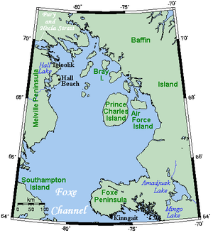
Sie liegt im Foxe Basin vor der Südküste von Baffin Island. Die Insel hat eine Fläche von 689 km².[1]
Bray Island war Standort von FOX-A, einer Station der Distant Early Warning Line. Heute befindet sich auf der Insel eine Einrichtung des North Warning System.
Einzelnachweise
Bearbeiten- ↑ Natural Resources Canada - The Atlas of Canada - Sea Islands ( vom 6. Oktober 2012 im Internet Archive)

