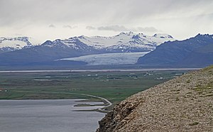
Fláajökull
Gletscher in Island
Fláajökull ist ein langsam fließender, kleinerer Gletscher Islands an der Ostseite des von Gletschern bedeckten Vulkans Breiðabunga im Osten Islands.
| Fláajökull | ||
|---|---|---|
 Blick vom Almannaskarð auf den Fláajökull | ||
| Lage | Island | |
| Länge | 15 km | |
| Breite | ⌀ 2 km | |
| Koordinaten | 64° 22′ N, 15° 39′ W | |
|
| ||
| Entwässerung | Hólmsá, Djúpá | |
Er ist ein Auslassgletscher des großen Gletschers Vatnajökull. Der Name leitet sich vom isländischen Wort flár für „Abhang“, „Gefälle“ oder „schräge Fläche“ ab.[1] Historische Namen des Gletschers sind Mýrajökull, Hólmsárjökull und Hólsárjökull.[1]
Er liegt im Vatnajökull-Nationalpark, 40 km Straße und 20 km Luftlinie nordwestlich der Kleinstadt Höfn.
Weblinks
BearbeitenCommons: Fláajökull – Sammlung von Bildern, Videos und Audiodateien
- Fláajökull Field trip and Excursion Report – Glacial geology (JAR407), University of Iceland – School of Engineering and Natural Science – Earth Science vom 22, 31. Mai 2012
- Oddur Sigurðsson1 und Richard S. Williams, Jr.: Geographic Names of Iceland’s Glaciers: Historic and Modern U.S. Department of the Interior, abgerufen am 5. Februar 2014
Einzelnachweise
Bearbeiten- ↑ a b Alphabetical List of the Glaciers of Iceland, U.S. Department of the Interior (usgs.gov), abgerufen am 5. Februar 2014
