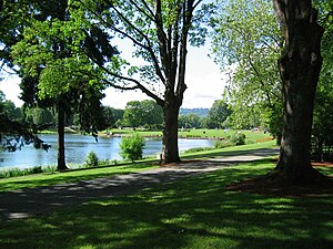
Lake Sacajawea (See, Washington)
See im US-Bundesstaat Washington
Der Lake Sacajawea ist ein kleiner See im Zentrum von Longview im US-Bundesstaat Washington. Er liegt innerhalb des Lake Sacajawea Park und ist eingebunden zwischen dem Kessler Boulevard und dem Nichols Boulevard. Seine Fläche beträgt 24,7 Hektar und wird vom Cowlitz River gespeist.[1][2][3][4]
| Lake Sacajawea | ||
|---|---|---|

| ||
| Geographische Lage | Longview, Washington, USA | |
| Zuflüsse | vom Cowlitz River | |
| Daten | ||
| Koordinaten | 46° 8′ 6″ N, 122° 57′ 7″ W | |
|
| ||
| Höhe über Meeresspiegel | 3 m | |
| Fläche | 24,7 ha | |
| Volumen | 435.419 m³ | |
| Umfang | 7,4 km | |
| Maximale Tiefe | 6,4 m | |
| Mittlere Tiefe | 1,8 m | |
| Einzugsgebiet | 12,9 km² | |
Weitere Daten des Sees sind: Einzugsgebiet 12,9 km², Durchschnittstiefe 1,8 Meter, Maximale Tiefe 6,4 Meter, Kapazitätvolumen 435.419 Kubikmeter, Uferlänge 7,4 Kilometer, Höhe über dem Meeresspiegel 3 Meter.[4]
Seit sieben Jahren wird an dem innerstädtischen See ein Angeltag für Kinder organisiert.[5]
Weitere Namen
BearbeitenWeitere Bezeichnungen des Sees sind:
Siehe auch
BearbeitenWeblinks
BearbeitenEinzelnachweise
Bearbeiten- ↑ Lake Sacajawea (See, Washington). In: Geographic Names Information System. United States Geological Survey, United States Department of the Interior (englisch).
- ↑ Photo #12135 - Lake Sacajawea, Longview Bordered by Kessler Blvd on the east and Nichols Blvd. on the west. Lake Sacajawea, a 60 acre lake within a 60 acre park - located in a... ( des vom 9. Juli 2008 im Internet Archive) Info: Der Archivlink wurde automatisch eingesetzt und noch nicht geprüft. Bitte prüfe Original- und Archivlink gemäß Anleitung und entferne dann diesen Hinweis.
- ↑ City of Longview, Washington: Lake Sacajawea Park
- ↑ a b Sacajawea SACCO1 (PDF-Datei; 68 kB)
- ↑ WDFW FISHING RULE CHANGE: Martin's Dock at Lake Sacajawea will close to public for Kids Fish-In
- ↑ U.S. Geological Survey. Geographic Names Phase I data compilation (1976–1981). 31-Dec-1981. Primarily from U.S. Geological Survey 1:24,000-scale topographic maps (or 1:25K, Puerto Rico 1:20K) and from U.S. Board on Geographic Names files. In some instances, from 1:62,500 scale or 1:250,000 scale maps
- ↑ Miscellaneous Sources - A brief description and the year of publication (if known) follow: 1961/Lakes of WA
- ↑ a b Hitchman, Robert. Place Names of Washington. State Historical Society, 1985. ISBN 0-917048-57-1.
- ↑ Miscellaneous Sources - A brief description and the year of publication (if known) follow: 1961/Lakes of WA
