Ramsey County (North Dakota)
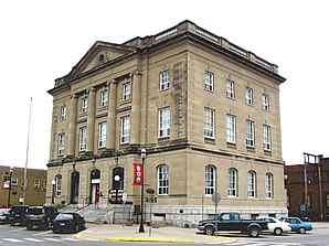
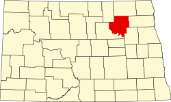
Ramsey County[1] ist ein County im Bundesstaat North Dakota der Vereinigten Staaten. Der Verwaltungssitz (County Seat) und mit Abstand größte Ort ist Devils Lake.
 | |
| Verwaltung | |
|---|---|
| US-Bundesstaat: | North Dakota |
| Verwaltungssitz: | Devils Lake |
| Adresse des Verwaltungssitzes: |
County Courthouse 524 4th Avenue Devils Lake, ND 58301-2490 |
| Gründung: | 1873 |
| Vorwahl: | 001 701 |
| Demographie | |
| Einwohner: | 11.605 (Stand: 2020) |
| Bevölkerungsdichte: | 3,78 Einwohner/km2 |
| Geographie | |
| Fläche gesamt: | 3369 km² |
| Wasserfläche: | 301 km² |
| Karte | |
 | |
| Website: www.co.ramsey.nd.us | |
Geographie
BearbeitenDas County liegt im mittleren Nordosten von North Dakota und hat eine Fläche von 3369 Quadratkilometern, wovon 301 Quadratkilometer Wasserfläche sind. Es grenzt im Uhrzeigersinn an folgende Countys: Cavalier County, Walsh County, Nelson County, Benson County und Towner County.
Das County liegt in der Drift Prairie, einer durch die letzte Kaltzeit geprägten Prärielandschaft mit zahlreichen Seen (Prairie Pothole Region). Im Südwesten bildet der Devils Lake die natürliche Grenze des Countys. Das Gebiet ist sehr flach und fällt von Nordwesten sanft zum See hin ab. Bis auf einen kleinen Teil im Osten des Countys entwässert das County in den Devils Lake. Dabei gibt es fast keine definierten Täler und Bäche, stattdessen fließt das Wasser an der Oberfläche und durch Entwässerungsgräben in den Devils Lake oder die anderen Seen und Teiche, die keinen Ausfluss haben (endorheische Seen). Das einzige größere Gewässersystem beginnt im Nordwesten als Trockental Edmore Coulee. Über die Seen Sweetwater Lake, Morrison Lake, Cavanaugh Lake, Dry Lake, Lake Alice, Lake Irvine und schließlich den Big Coulee an der Grenze zum Benson County kann das Wasser bis in den Devils Lake fließen. Meist liegt der Niederschlag allerdings unter der Verdunstungsrate, sodass es nicht zum Überlauf zwischen den Seen kommt. Manche Seen fallen gelegentlich sogar trocken.[2]
Geschichte
BearbeitenDas Ramsey County wurde 1873 von der Legislative des Dakota-Territoriums gebildet und nach Alexander Ramsey, einem US-Senator aus Minnesota, benannt. Die tatsächliche Verwaltung des Countys wurde aber erst am 25. Januar 1883 gegründet.[3] Als County Seat wurde Devils Lake City bestimmt, ein Ort unweit der heutigen Stadt Devils Lake (ehemals Creel City oder City of Devils Lake). Als die Eisenbahn Creel City erreichte und Devils Lake City bedeutungslos wurde, versetzte man das Courthouse dorthin.[4]
| Bevölkerungswachstum | |||
|---|---|---|---|
| Census | Einwohner | ± rel. | |
| 1880 | 281 | — | |
| 1890 | 4.418 | 1.472,2 % | |
| 1900 | 9.198 | 108,2 % | |
| 1910 | 15.199 | 65,2 % | |
| 1920 | 15.427 | 1,5 % | |
| 1930 | 16.252 | 5,3 % | |
| 1940 | 15.626 | −3,9 % | |
| 1950 | 14.373 | −8 % | |
| 1960 | 13.443 | −6,5 % | |
| 1970 | 12.915 | −3,9 % | |
| 1980 | 13.048 | 1 % | |
| 1990 | 12.681 | −2,8 % | |
| 2000 | 12.066 | −4,8 % | |
| 2010 | 11.451 | −5,1 % | |
| 2020 | 11.605 | 1,3 % | |
| Aus Volkszählungsergebnissen | |||
15 Bauwerke und Stätten des Countys sind insgesamt im National Register of Historic Places eingetragen (Stand April 2021).[5] Außer einem ehemaligen jüdischen Friedhof (Sons of Jacob Cemetery) liegen alle in der Stadt Devils Lake.
Orte
BearbeitenIm Ramsey County liegen sieben Gemeinden (City) sowie mehrere Orte ohne eigene Verwaltung. Das gemeindefreie Gebiet ist in 36 Townships eingeteilt.[6]
Gemeinden
Bearbeiten- Brocket
- Crary (ehemals Midway)
- Devils Lake
- Edmore
- Hampden (ehemals Northfield)
- Lawton
- Starkweather
Weitere Orte
Bearbeiten- Bartlett (48° 3′ N, 98° 26′ W)[7]
- Camp Grafton (auch Camp Burke, C. Hanna, C. Laghton, 48° 3′ N, 98° 55′ W)[8]
- Churchs Ferry (census-designated place)
- Darby (48° 9′ N, 98° 58′ W)[9]
- Derrick (48° 29′ N, 98° 33′ W)[10]
- Doyon (48° 3′ N, 98° 32′ W)[11]
- Essex (48° 7′ N, 98° 45′ W)[12]
- Garske (48° 21′ N, 98° 53′ W)[13]
- Grand Harbor (ehemals Scott, 48° 10′ N, 98° 59′ W)[14]
- Keith (ehemals Keildahl, 48° 6′ N, 98° 45′ W)[15]
- Lakewood Park (48° 4′ N, 98° 56′ W)[16]
- Penn (ehemals Lauren, 48° 13′ N, 99° 5′ W)[17]
- Ramsey (48° 9′ N, 99° 5′ W)[18]
- Rohrville (48° 9′ N, 98° 40′ W)[19]
- Saint Joe (48° 31′ N, 98° 56′ W)[20]
- Southam (48° 10′ N, 98° 33′ W)[21]
- Sweetwater (48° 13′ N, 98° 52′ W)[22]
- Webster (48° 17′ N, 98° 53′ W)[23]
Townships
Bearbeiten- Bartlett
- Cato
- Chain Lakes
- Coulee
- Creel
- DeGroat
- Dry Lake
- Fancher
- Freshwater
- Grand Harbor
- Hammer
- Harding
- Highland Center
- Hope
- Klingstrup
- Lawton
- Lillehoff
- Minnewaukan
- Morris
- Newbre
- Newland
- Noonan
- North Creel
- Northfield
- Odessa
- Ontario
- Overland
- Pelican
- Poplar Grove
- Prospect
- Royal
- South Minnewaukan
- Stevens
- Sullivan
- Triumph
- Webster
Weblinks
BearbeitenEinzelnachweise
Bearbeiten- ↑ Ramsey County. In: Geographic Names Information System. United States Geological Survey, United States Department of the Interior (englisch).
- ↑ Howard C. Hobbs, John P. Bluemle: Geology of Ramsey County, North Dakota. In: North Dakota Geological Survey (Hrsg.): County ground water studies. Band 26, 1987, ISSN 0546-5001, S. 4–6 (englisch, nd.gov [PDF]).
- ↑ County History. In: nd.gov. Abgerufen am 22. April 2021 (englisch).
- ↑ Ramsey County. In: Alfred Theodore Andreas (Hrsg.): Historical atlas of Dakota, 1884. Chicago 1884 (englisch, usgenwebsites.org).
- ↑ Suchmaske Datenbank im National Register Information System. National Park Service, abgerufen am 24. April 2021.
- ↑ Townships. In: Ramsey County, ND. Abgerufen am 22. April 2021 (englisch).
- ↑ Bartlett. In: Geographic Names Information System. United States Geological Survey, United States Department of the Interior (englisch).
- ↑ Camp Grafton. In: Geographic Names Information System. United States Geological Survey, United States Department of the Interior (englisch).
- ↑ Darby. In: Geographic Names Information System. United States Geological Survey, United States Department of the Interior (englisch).
- ↑ Derrick. In: Geographic Names Information System. United States Geological Survey, United States Department of the Interior (englisch).
- ↑ Doyon. In: Geographic Names Information System. United States Geological Survey, United States Department of the Interior (englisch).
- ↑ Essex. In: Geographic Names Information System. United States Geological Survey, United States Department of the Interior (englisch).
- ↑ Garske. In: Geographic Names Information System. United States Geological Survey, United States Department of the Interior (englisch).
- ↑ Grand Harbor. In: Geographic Names Information System. United States Geological Survey, United States Department of the Interior (englisch).}
- ↑ Keith. In: Geographic Names Information System. United States Geological Survey, United States Department of the Interior (englisch).
- ↑ Lakewood Park. In: Geographic Names Information System. United States Geological Survey, United States Department of the Interior (englisch).
- ↑ Penn. In: Geographic Names Information System. United States Geological Survey, United States Department of the Interior (englisch).
- ↑ Ramsey. In: Geographic Names Information System. United States Geological Survey, United States Department of the Interior (englisch).
- ↑ Rohrville. In: Geographic Names Information System. United States Geological Survey, United States Department of the Interior (englisch).
- ↑ Saint Joe. In: Geographic Names Information System. United States Geological Survey, United States Department of the Interior (englisch).
- ↑ Southam. In: Geographic Names Information System. United States Geological Survey, United States Department of the Interior (englisch).
- ↑ Sweetwater. In: Geographic Names Information System. United States Geological Survey, United States Department of the Interior (englisch).
- ↑ Webster. In: Geographic Names Information System. United States Geological Survey, United States Department of the Interior (englisch).
Koordinaten: 48° 15′ N, 98° 43′ W