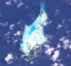
Strathord-Inseln
unbewohnte Pazifikinseln
Die Strathord-Inseln sind eine unbewohnte Inselgruppe in der Salomonensee. Politisch gehören sie zur Provinz Milne Bay im südöstlichen Bereich von Papua-Neuguinea.
| Strathord-Inseln | ||
|---|---|---|
 | ||
| Gewässer | Salomonensee | |
| Archipel | Bonvouloir-Inseln (Louisiade-Archipel) | |
| Geographische Lage | 10° 15′ S, 151° 52′ O | |
|
| ||
| Anzahl der Inseln | 5 | |
| Hauptinsel | Strathord Island | |
| Gesamte Landfläche | 1,34 km² | |
| Einwohner | unbewohnt | |
Die Inseln befinden sich etwa 100 km nordwestlich von Misima und bilden die nördlichste Gruppe des Louisiade-Archipels. Sie zählen zu den Bonvouloir-Inseln, zu denen auch das etwa 9 km südlich gelegene Hastings Island und das über 30 km südöstlich gelegene East Island gehört.
Die Hauptinsel Strathord Island liegt am südlichen Riffkranz der Gruppe, ist dicht bewaldet und flach.
Inseln
Bearbeiten| Name | Koordinaten | Fläche km² |
|---|---|---|
| North Island | 10° 13′ 29″ S, 151° 52′ 1″ O | 0,18 |
| Middle Island | 10° 14′ 13″ S, 151° 51′ 51″ O | 0,08 |
| Amanuta | 10° 14′ 32″ S, 151° 51′ 41″ O | 0,05 |
| (unbenannt) | 10° 15′ 17″ S, 151° 50′ 59″ O | 0,04 |
| Strathord Island | 10° 15′ 22″ S, 151° 51′ 36″ O | 0,99 |
